
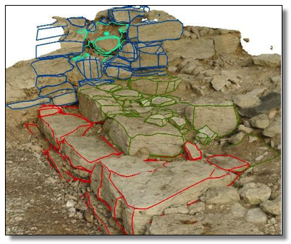
The generated model of the ruins was georeferenced using geodata from the 2D documentation, though this caused some issues due to the limited height-data available. Following this it was possible to document the church from a 3D perspective by utilizing GIS software and documenting all features of interest, linking them to a database containing information of the feature; such as building-phase, chronology, related finds or construction method. Though this is fully possible to do from a 2D/top-down perspective, the 3D allows for a direct visualization of the height relations between features, which would otherwise be omitted by the 2D view. A 3D documentation of the site allows for direct access to the relations between any two features in the model, making advanced spatial and geometrical analysis possible. Using the position of some of the coins found at the site, along with the positions of floor traces, two TIN’s were generated (green and red representing floor traces and coin positions respectively). These properly visualize the relations between the two categories, both in terms of spatiality in the church as well as in terms of height relations to one another. The possibilities for further analysis is quite limitless, depending solely on the initial documentation of the site, which lends to the importance of approaching sites with a 3D mentality.
The aim of the project was to complement the documentation of the church ruins, but also to point out the advantages of utilizing a 3D mentality towards spatial documentation. This is a very important topic of discussion, as a 2D documentation perhaps no longer holds to the scientific standards of our time. Instead, a 3D approach allows for a deeper understanding of the relations between features and opens up for a whole new range of documentation techniques and analyses, while also allowing for a certain transparency, since the model itself is arguably more objective than traditional documentation.
 The project successfully raised the standard of the documentation of the church ruins and allowed for a more in-depth and detail-oriented documentation and analysis. It also demonstrated the advantages of utilizing a 3D mentality and technical approach towards an archaeological context, as it allows for an objective representation of the site, allowing for advanced analysis and detailed documentation.
3D dokumentasjon av kirkegravning på Gotland.