
Scientific analyses, especially provenance studies, plays an important role, and several associated projects are developing methods and baseline data for analysing the Gokstad material.
Viken in the Viking Age – a contested region
Eastern Norway was a contested region throughout the Viking Age, and it was not until the 11th century that it more permanently became a part of the Norwegian kingdom. For that reason it appears likely that monumental Viking Age burials in the region was connected to ongoing struggles for dominance and that this is a meaningful perspective for an analytical approach. Gokstad revitalised is based on an understanding of the Gokstad burial as a manifestation of the deceased's social position, created by peers who needed to make his memory immortal in order to secure the transition of his position to themselves and their lineage. This puts his social identity, or rather, his social identity such as it was staged by the organisers of his burial, to the core of this research project. In part this identity was articulated through the objects and animals that he was given to accompany him in the burial, in part it was formulated through the acts or rituals carried out before, during and after the burial - but also the choice of place for the burial and the monument can be assumed to be essential for its intended message. Therefore Gokstad revitalised has been built up as a concentric research project with the remains of the deceased as the most central and most direct evidence about his social identity, and then moving stepwise towards increasingly more peripheral, and more indirect, layers of evidence.
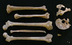 The human remains from the Gokstad burial. Photo: Per Holck.
Investigation of the human remains
During the excavation only a fragment of the skull, an incomplete shoulder blade and five of the major bones from arms and legs were found. These have recently been scrupulously investigated after being recovered in 2007 from their deposition there in 1928, and has contributed essential information about the man's stature, age, pathology and cause of death. Some questions still remain, however. A study of his diet and place of living in the last decades before his death will be carried out by means of isotope analyses, and may help to illuminate the important question whether the Gokstad man lived in the region or not. An associated project, SIGMA, is aiming at providing base-line data for comparing the Gokstad man with other skeletons surviving from the later Iron Age in Norway - including DNA.
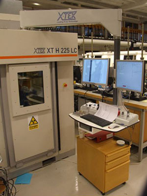 X-ray microtomograph at the Norwegian Geotechnical Institute.
Provenancing the grave goods
The grave goods include objects made of many different materials: wood, iron, lead, copper alloys, gold, wool, plus a large number of animals: horses, dogs, peafowl and hawks. Together, they hold the potential of revealing aspects of the network surrounding the Gokstad man. An associated project, DendroCT, has been carried through to develop a non-destructive method for dendrochronology, in order to allow dendrochronological dating and provenancing of the wooden objects from Gokstad. Another project, Iron Origins, is in progress and will provide the possibility and base-line data to provenance iron objects from the grave. Copper alloys and lead will be provenanced using isotope analyses, as will the animal skeletons. Further osteological and aDNA analyses of the animal bones will help illuminate the stature and use of the sacrificed animals, thus further illuminating the Gokstad man's social status.
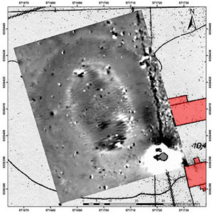 Geophysic survey of Kongshaugen where the burial was found.
Investigating the grave mound
Beneath the reconstructed mound which stands at the site today there are remains preserved of the original mound. Based on studies of documentation from the 1880-excavation and supplementary investigations prior to the reconstruction of the mound in 1928, together with geophysical survey of the mound today, the extent of the preserved mound remains will be mapped. This will form the basis for a renewed investigation of the mound with drilling and possibly limited excavations, to answer questions about the original extent of the mound, its construction sequences and time of construction, the origin of the materials in the mound, as well as the use of the land prior to its construction. This will enhance our understanding of the extent and character of the mound building process, as well as of the landscape in which it was situated.
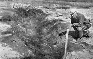 Boat grave excavated 1944 a few hundred meters to the south of the Gokstad mound.
Surveying and excavating in the landscape around the mound
It is known that several smaller and at least one larger mound was found in the vicinity of the Gokstad burial, but only one of these burials, a Viking Age boat burial has been excavated. Search trenches has also revealed that close to some of these mounds, at the contemporary coast line, an activity area with light buildings and workshop activities, also dating to the Viking Age, existed. The project will map this area with Lidar scan and geophysical surveys, and conduct excavations to date the burials and to illuminate the character and chronological framework of the activities on the shore site. Further, through detector and geophysical survey it will be investigated if any settlement sites can be located on the higher lands at the sides of the valley in which the burial is situated. If so, excavations will be carried out to date and establish the character of these settlements.
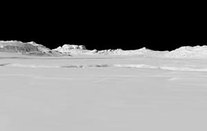 LIDAR scan of the mound's surroundings, seen from N.
Landscape archaeological analyses
The Gokstad burial is situated at what seems to be a bottleneck passage for the land traffic along the west coast of the Oslo fjord, and at a well protected natural harbour. An analysis of the younger Iron Age and early medieval settlement pattern in the area, combined with place-name studies and a transport-geographical analysis, will attempt to reconstruct the landscape use in the Viking Age, and place the Gokstad site in this context. For these analyses, archaeological data and survey data (e.g., satellite, aerial photography, LIDAR scanning) will be used together with historical sources as cadastres, letters and historical maps.
Historical context
Gokstad revitalised is a project within the field of historical archaeology, and in part its research problem is formulated on the basis of knowledge about the political situation in Eastern Norway that derive from historical sources. It is therefore necessary, in the end of the project, to confront the findings from the above analyses with the historical sources, to see if the two set of data can supplement or illuminate each other.
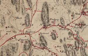 Historical map from 1826, showing the vicinity of the mound.
Publication and dissemination
The final scientific outcome of Gokstad revitalised will be published in one or more monographs with a thematic structure focusing on a) the Gokstad man, his status and network; b) the landscape and settlement structure around Gokstad in the Viking Age; and c) the Gokstad burial in its historical context. Especially important part-results will be published in peer-reviewed journals as they appear, and preliminary results will be presented on conferences and in conference proceedings.
Dissemination to the public will take place through a number of channels: Through dedicated home pages by the project partners, through Wikipedia and Google Maps, through temporary exhibitions in Sandefjord, in the Historical Centre Midgard at Borre and at the Viking Ship Museum on Bygdøy, through public lectures and through a mobile dissemination unit used on site in connection with field activities.
(last edited on 27.03.2011)